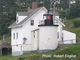
Brown's Head Light
Brown's Head Light
Nearby town:
Vinalhaven, ME
Established:
1832
Year Light First Lit:
1857
Lighthouse Automated:
1987
Lighthouse Operational:
Yes, active aid to navigation
Tower Height: 20 feet
Present Optics:
Fourth Order Fresnel
Accessibility:
By boat & car ferry; can also be viewed by boat tour
Open to public:
Yes, grounds open to public
Brown's Head Light - near the northwest corner of Vinalhaven, it marks the popular seaway between Vinalhaven and North Haven
 Vinalhaven is a large island, located off the coast of Rockland, in the middle of Penobscot Bay. It is one of the “Fox Islands,” a group of islands named after the gray foxes that once inhabited them. In the second half of the 19th Century, Vinalhaven was home to a thriving granite industry. (Granite was shipped from the area for the Washington Monument and the Brooklyn Bridge.) It was this industry, as well as the fishing industry, that led President Andrew Jackson to appropriate $4,000 for the development of Brown's Head Light in 1832.
Brown's Head Light (+44° 6' 42.35", -68° 54' 34.19") is located near the northwest corner of the island, marking the popular seaway between Vinalhaven and North Haven. Jeremiah Berry of East Thomaston built the original rubblestone tower and dwelling.
 The original keeper, David Wooster of North Haven, served until his death in 1841. In 1904, the Boston Globe published an article about Keeper Benjamin Eldridge Burgess. The article described Burgess as “a good man, a good servant of Uncle Sam, and a saver of countless lives.” Ernest DeRaps, the keeper in 1961, wrote that the dwelling was so close to the water that storms often sent spray flying against the second story windows. During one snowstorm, DeRaps had to tie his six-year-old son to himself with a rope so that he wouldn't be blown away as they trudged through 2 feet of snow to get to their truck.
In 1857, a new one-and-a-half story, wood-frame house was constructed and connected via a short, covered passageway to a new cylindrical, 20-foot tall, brick tower. A fifth-order Fresnel lens was installed and a bell tower with a 1,000 pound fog bell was added. In 1902, the fifth-order Fresnel was replaced by a fourth-order Fresnel, which remains in service today. The light's characteristic is fixed white with two red sectors. The light is 39 feet above sea level, with a range of 13 miles. In 1903, an oil house was added. In 1987, Brown's Head Light became automated. The bell tower was torn down and the bell is now on display at the Vinalhaven Historical Museum. A fog signal took its place and sounds one blast every 10 seconds in the event of limited visibility.
The lighthouse is owned by the town, and the town's manager lives in the dwelling. The grounds are open to the public, but the tower and dwelling are closed. To reach the lighthouse by ground, from the island's ferry terminal, travel 6 miles NW to the end of Brown's Head Light Road.
Brown's Head Light is listed on the National Register of Historic Places.
Photos by Robert English. We would like to thank Robert English for granting us permission to use his images of Brown's Head Light. You can view more images of Brown's Head Light and Maine Lighthouses by visitng Robert's Flickr page.


